

07 Oct Master Four Units With Examiner Tips for IB Geography Freshwater
IB Geography Option A (Freshwater) tests your ability to apply a systems framework to drainage basins, floods, scarcity, water quality, and management futures. The strongest answers treat facts as evidence inside that framework rather than as a list to recite. This guide walks through the syllabus, shows you how to build case dossiers that actually earn marks, and gives examiner-style tips you can use in your next practice paper.
TL;DR:
- Understanding basin inputs, stores, transfers, and outputs is crucial for applying a systems framework to freshwater questions, especially in landform and water flow analysis.
- Flood mitigation strategies must be evaluated based on specific trade-offs, with hard engineering offering short-term solutions and soft measures supporting ecosystems but requiring longer implementation.
- Definitions of water scarcity and stress are distinct; scarcity is volume-based while stress depends on the withdrawal-to-supply ratio, affecting how risks are justified and managed.
- The GERD case provides measurable data and model-based insights, demonstrating how coordinated management can mitigate drought risk and influence downstream water availability.
- Effective internal assessments focus on specific, measurable questions with clear data sources, justified sampling, and explicit links to the systems model to improve scoring and understanding.
Table of Contents
- IB Option A syllabus mapped to exam tasks
- Drainage basin hydrology and geomorphology using the systems framework
- Flooding: causes, impacts, and evaluating mitigation options
- Water scarcity and water quality: clear definitions and indicators
- Water management futures and IWRM: trade-offs students should evaluate
- Case studies: using the GERD and one contrasting case
- Examiner and tutor advice: IA, EE, and exam technique
- Groundwater and aquifer systems: recharge, usage, and depletion
- Human impacts on freshwater systems beyond flooding and pollution
- Climate change effects on freshwater resources and hydrological cycles
- Water conflict and political dimensions related to freshwater resources
- Tutor perspective: how to study freshwater geography effectively
- How Esstutor can help with freshwater topics
- FAQ
- Sources
IB Option A syllabus mapped to exam tasks
Freshwater sits inside four connected units, and examiners expect you to move between them rather than treat each as a separate topic. Knowing a fact is not enough: you need to apply it to a scenario, then evaluate what it means for people and places.
- Drainage basin hydrology and geomorphology: know the systems model and link it to landform processes.
- Flooding and flood mitigation: explain causes, then evaluate hard and soft engineering responses.
- Water scarcity and water quality: define key terms precisely and use indicators to support judgments.
- Water management futures: compare integrated approaches and weigh the trade-offs they involve.
At HL, you’re expected to handle more quantitative data and push further into evaluation and synthesis, while SL answers can stay more descriptive but still need clear structure. Every exam question traces back to one of these four bullet points, so when you plan an answer, name the unit it belongs to first.
Drainage basin hydrology and geomorphology using the systems framework
A drainage basin is a system: it has inputs, stores, transfers, and outputs, and examiners want you to name each one and connect it to a measurable variable rather than describe it vaguely.
- Inputs include precipitation and snowmelt, measured in millimeters per day.
- Stores include soil moisture, groundwater, and surface water, measured by soil moisture probes or well depth.
- Transfers include infiltration, throughflow, and channel flow, tracked through discharge readings.
- Outputs include evapotranspiration and river discharge at a gauging station, often shown on a hydrograph.
For an internal assessment, simple field methods work well: timing a float across a measured channel section for discharge, reading a staff gauge before and after rainfall, or sieving sediment samples to compare particle size downstream. A common pitfall is describing a hydrograph’s shape without explaining why it rises or falls, so always tie peak discharge and lag time back to basin characteristics like slope, soil type, or land cover.
Pro Tip: Draw a labeled systems diagram first, even in an essay question: it keeps your explanation anchored to inputs, stores, transfers, and outputs instead of drifting into description.
Flooding: causes, impacts, and evaluating mitigation options
Floods result from a mismatch between how much water a channel can carry and how much arrives, so your explanation should separate the trigger from the underlying vulnerability. Intense rainfall, snowmelt, and storm surges are common physical triggers, while urbanization, deforestation, and floodplain development raise the risk by reducing infiltration and increasing runoff speed.
Impacts are easier to structure when you sort them by category:
- Social: displacement, disease risk, and disruption to schooling or healthcare access.
- Economic: crop loss, damaged infrastructure, and rebuilding costs.
- Environmental: soil erosion, habitat disturbance, and sediment redistribution.
For mitigation, hard engineering options like levees, dams, and channelization offer reliable short-term protection but can be costly and sometimes shift flood risk downstream. Soft and nature-based measures, such as floodplain zoning, wetland restoration, and afforestation, tend to cost less and support ecosystems, though they can be slower to take effect and harder to scale in dense urban areas. A strong evaluation names a specific trade-off rather than simply listing pros and cons.
Water scarcity and water quality: clear definitions and indicators
Precise definitions matter more in this unit than almost anywhere else in the syllabus, because scarcity and stress are often confused. Physical scarcity describes a situation where renewable freshwater supply falls below roughly 1,000 cubic meters per person per year, while water stress measures the ratio of withdrawals to renewable supply, with high stress typically defined above 40%. The UN World Water Development Report draws this same distinction, noting that scarcity is a volume concept while stress reflects how intensively a supply is used.
A significant portion of the world’s population faces extremely high water stress, using a very high proportion of its renewable freshwater supply, according to the UN World Water Development Report. That figure is worth citing whenever an exam question asks you to justify why stress and scarcity are not interchangeable.
Key drivers include population growth, climate variability, and agricultural demand, since agriculture accounts for a large majority of global freshwater withdrawals. For water quality, examiners expect you to name indicators precisely:
- pH and dissolved oxygen reveal pollution load and aquatic habitat health.
- Turbidity signals sediment or runoff contamination.
- Nitrate levels point to agricultural fertilizer runoff and risk of eutrophication.
Water management futures and IWRM: trade-offs students should evaluate
Integrated Water Resources Management (IWRM) treats water as a shared resource across sectors and borders rather than a problem to solve in isolation. Policy tools include allocation agreements between users, pricing mechanisms that reflect scarcity, and transboundary treaties between countries sharing a river basin.
The trade-offs are where exam marks are won or lost:
- Hydropower versus downstream supply: generating electricity upstream can reduce flow reliability for farmers and cities downstream.
- Evaporation losses: large reservoirs in hot climates can lose substantial volumes to evaporation, reducing the water actually delivered.
- Sedimentation: dams trap sediment that would otherwise replenish downstream floodplains and deltas.
Strong evaluation draws on concrete evidence types rather than general claims: Earth observation data showing reservoir extent over time, or hydrological models projecting flow under different operating scenarios, both give you something specific to cite.
Case studies: using the GERD and one contrasting case
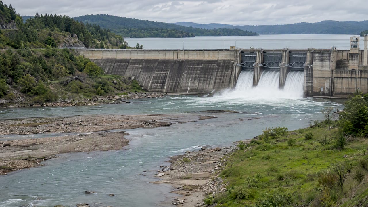
The Grand Ethiopian Renaissance Dam (GERD) is a dependable case because it has clear figures and a well-documented set of trade-offs. Its reservoir has a storage capacity of around 74 billion cubic meters, and peer-reviewed modeling shows that coordinated operation with downstream reservoirs in Sudan and Egypt can reduce drought risk, but only when data sharing and agreed policies are in place, according to research published in Nature Communications. Earth observation analysis using Sentinel-2 imagery found that the GERD’s water spread area grew from about 80 square kilometers in 2019 to roughly 528 square kilometers in 2022, a change documented in transboundary water governance research that also noted downstream water extent at Sudan’s Roseires Dam fell over the same period.
To build an answer, follow this structure:
- Claim: state what the dam’s operation affects (for example, downstream flow reliability).
- Evidence: cite a specific figure, such as the reservoir storage or water spread change above.
- Systems link: trace the effect through inputs, stores, or outputs in the basin.
- Evaluation: weigh who benefits and who bears the cost, and under what conditions the impact changes.
Pairing GERD with a contrasting case, such as a seasonal urban flood or a local water-quality dispute, lets you compare scale and governance rather than repeating the same example twice.
Pro Tip: Keep four to six case facts per dossier, each with a source and a figure, so you can slot them into any question type without scrambling for details in the exam.
Examiner and tutor advice: IA, EE, and exam technique
Internal assessments and extended essays on freshwater topics succeed or stall based on design choices made before any data is collected. A clear checklist helps:
- Research question: narrow it to a specific location, variable, and timeframe.
- Sampling: justify your method, whether systematic, stratified, or random, and state sample size.
- Data reliability: note sources of error and how you minimized them.
- Ethical consent: confirm permissions for fieldwork on private or sensitive land.
The IB Extended Essay guidance stresses integrating data sources, including satellite observations, and building a clear spatial argument rather than a descriptive narrative. For exam technique, write evaluation sentences that name a specific condition (“this trade-off intensifies during drought years”) instead of generic statements like “there are pros and cons.” If you use satellite or EO data, state the dataset and date range in one sentence rather than describing the imagery at length.
Groundwater and aquifer systems: recharge, usage, and depletion
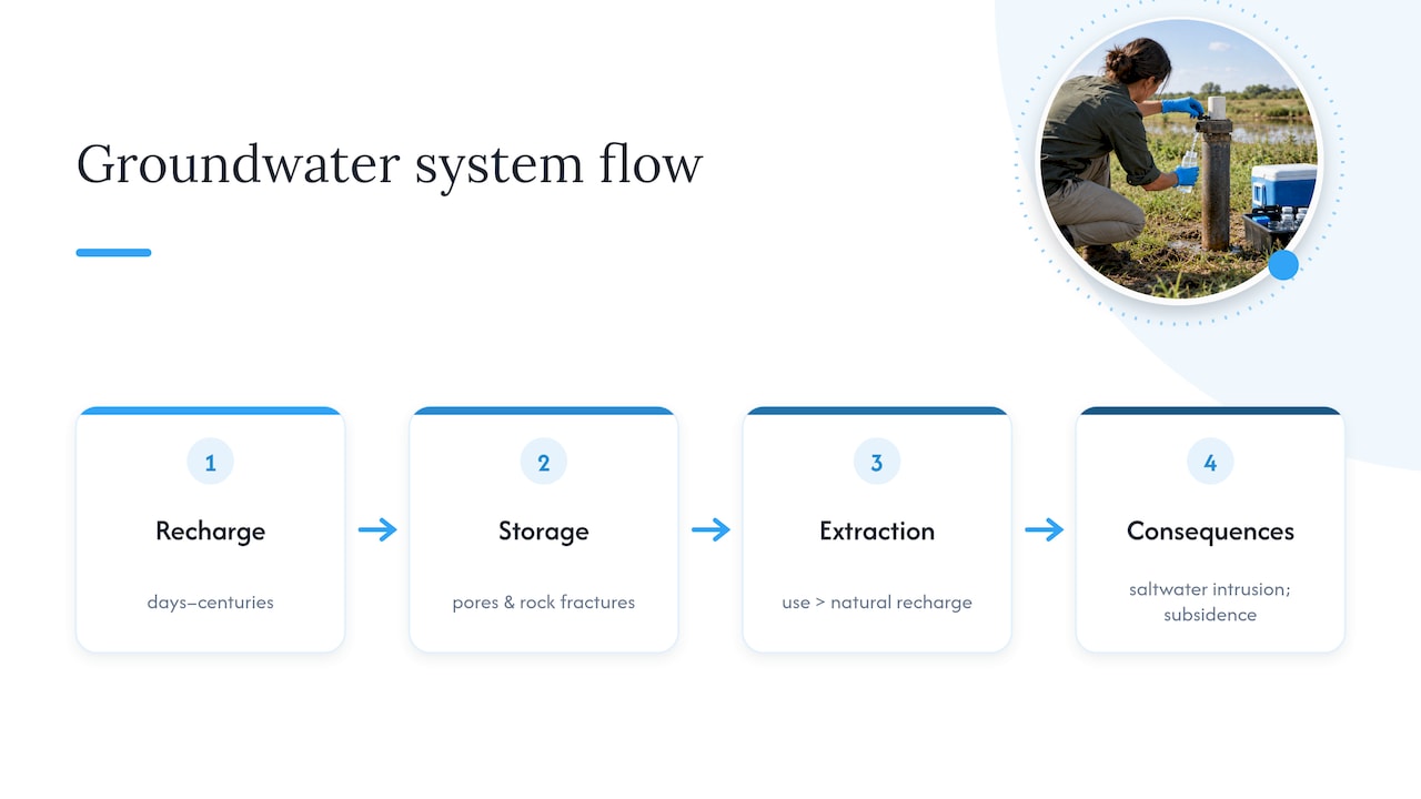
Groundwater is the water stored in soil pores and rock fractures below the surface, and it supplies a significant share of drinking water and irrigation in many regions. An aquifer recharges when precipitation or surface water infiltrates through permeable rock, a process that can take anywhere from days to centuries depending on the rock type and depth. Confined aquifers, sealed by impermeable layers above, recharge far more slowly than unconfined ones exposed directly to surface infiltration.
Overuse becomes a problem when extraction outpaces recharge, a situation common in arid and semi-arid regions where agriculture relies heavily on wells. The result is a falling water table, which forces deeper and more expensive drilling, and in coastal areas can trigger saltwater intrusion as seawater moves in to replace the lost freshwater. Land subsidence is another consequence: as aquifers lose water, the ground above can compact and sink, sometimes permanently reducing the aquifer’s future storage capacity.
For exam answers, link groundwater depletion back to the systems framework: it’s a store being depleted faster than inputs can refill it. A strong paragraph names a specific use (irrigation, urban supply), explains why extraction has outpaced recharge in that context, and evaluates a management response such as extraction limits, artificial recharge schemes, or crop switching to reduce demand. Avoid treating groundwater as a separate topic from the drainage basin system; it’s simply a store with a longer residence time than surface water.
Human impacts on freshwater systems beyond flooding and pollution
Dams and land use changes reshape freshwater systems in ways that go beyond the headline issues of flooding and pollution. A dam doesn’t just store water: it traps sediment that would otherwise travel downstream, which can starve deltas and floodplains of the material that maintains their shape and fertility over time. It also alters the timing of flow, smoothing out natural seasonal peaks that many downstream ecosystems and farming calendars depend on.
Land use change affects freshwater systems just as directly. Converting forest to agriculture or urban surfaces reduces interception and infiltration, so more rainfall becomes rapid surface runoff instead of slowly recharging soil moisture and groundwater stores. This speeds up a basin’s response to rainfall, often raising peak discharge and shortening lag time, a shift you can describe directly in hydrograph terms.
Wetland drainage for agriculture or development removes a natural store that would otherwise buffer flow and filter pollutants, so its loss tends to show up as both more erratic discharge and lower water quality downstream. When you write about human impact, name the specific mechanism: is it a change to a store, a transfer, or an output? That precision is what separates a descriptive paragraph from an analytical one.
Climate change effects on freshwater resources and hydrological cycles
Climate change is altering the input side of the freshwater system first, through shifts in precipitation timing, intensity, and seasonal distribution. Some regions are seeing more intense rainfall events concentrated into fewer days, which increases flood risk even where total annual rainfall stays roughly constant. Other regions face longer dry spells between rain events, which stresses both surface stores and groundwater recharge.
Rising temperatures also increase evapotranspiration rates, pulling more water out of soil and surface stores even without a change in rainfall. Freshwater ecosystems are particularly exposed to these shifts: impacts play out across individual species, food webs, and whole ecosystems, often interacting with other stressors like pollution or habitat loss, according to research on freshwater biodiversity.
Glacial and snowmelt-fed rivers add another layer of change. As glaciers retreat and snowpack shrinks, the timing of peak flow shifts earlier in the year, which can disrupt irrigation schedules and reduce dry-season flow when water is often needed most. For an exam answer, link a specific climate shift (more intense rainfall, earlier snowmelt, higher evapotranspiration) to a specific part of the systems model, then evaluate the consequence for a named user group, whether that’s farmers, a city’s water utility, or a downstream ecosystem.
Water conflict and political dimensions related to freshwater resources
Freshwater rarely respects political borders, and that mismatch is often the root of conflict when a river basin is shared across multiple countries. Upstream development, whether a new dam, an irrigation scheme, or industrial withdrawal, can reduce flow reliability for downstream nations, creating tension even without any single dramatic event. The GERD case illustrates this directly: downstream countries have raised concerns over filling speed and future operation, while the dam’s modeled benefits depend heavily on coordinated management and transparent data sharing between all parties, as the Nature Communications analysis outlines.
Political dimensions extend beyond international basins to domestic allocation disputes, where agricultural, industrial, and urban users compete for the same limited supply, often mediated through pricing, permits, or court rulings. Economic scarcity, where water exists physically but infrastructure or governance fails to deliver it, adds another layer: a well-governed region can manage moderate physical stress, while poor governance can turn even modest scarcity into crisis.
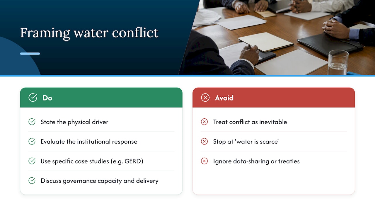
For essays and IAs, frame water conflict as a governance problem layered on top of a physical one. State the physical driver (shared basin, seasonal variability, growing demand), then evaluate the institutional response (treaty, data-sharing agreement, pricing reform) rather than treating conflict as inevitable. That framing consistently scores higher than a narrative that stops at “water is scarce, so conflict follows.”
Tutor perspective: how to study freshwater geography effectively
I’d rather see you master four strong case dossiers than skim ten. Build each one with a figure, a source, and a systems link, then practice slotting it into different question types under timed conditions. Use your IA to show real data skills: a clean sampling method and an honest discussion of its limits will carry more weight than an elaborate setup with weak follow-through.
— Marija
How Esstutor can help with freshwater topics
We built our tutoring around exactly the gap most students hit with Option A: knowing the facts but struggling to link them into a systems answer under exam pressure. Working one-on-one with an experienced tutor, you get direct feedback on how your paragraphs are scored, not just whether your facts are correct.
- Trial lesson: a low-commitment way to see how our feedback style fits your learning before booking a full package.
- IA and EE feedback: structured review of your research question, sampling design, and data analysis before you submit.
- Focused revision sessions: targeted practice on case-study application and evaluation writing for Option A.
If you want a second pair of eyes on your drainage basin IA or your GERD case paragraph, our pricing page lays out the trial lesson and tutoring packages so you can book a session built around what you actually need to improve.
FAQ
What does IB Geography Option A Freshwater actually cover?
Option A covers four units: drainage basin hydrology and geomorphology, flooding and its mitigation, water scarcity and water quality, and water management futures. Exams expect you to apply a systems framework (inputs, stores, transfers, outputs) across all four rather than treat them as separate topics.
What is the difference between water scarcity and water stress?
Water scarcity is a per-capita volume measure, typically defined as physical scarcity below 1,000 cubic meters per person per year. Water stress measures how intensively a renewable supply is used, calculated as the ratio of withdrawals to renewable supply, with high stress usually defined above 40%.
Why is the GERD a good case study for IB Geography essays?
The GERD offers clear figures, such as its reservoir storage capacity of roughly 74 billion cubic meters, and well-documented trade-offs between hydropower generation and downstream water supply, as shown in peer-reviewed modeling research. It also demonstrates how coordinated operation and data sharing between countries can change the outcome, which gives you material for both factual and evaluative answers.
How do I choose a strong research question for a freshwater IA?
Narrow your question to a specific location, a measurable variable, and a clear timeframe, such as comparing discharge at two points on a stream after a rainfall event. A focused question with a justified sampling method tends to score higher than a broad one that tries to cover too much ground.
Can Esstutor help with my IB Geography Internal Assessment?
Yes, our tutoring includes direct feedback on IA design and analysis, delivered by an experienced IB tutor. Details on packages and the trial lesson are available on our pricing page.
Sources
- Water for Prosperity and Peace | UN World Water Development Report
- Understanding and managing new risks on the Nile with the Grand Ethiopian Renaissance Dam | Nature Communications
- Enhancing transboundary water governance using African Earth Observation data cubes in the Nile River Basin (MDPI)
- IB Extended Essay guidance (geography) — IBO
No Comments